

I have had my eye on hiking to Havasu Falls for quite a while. Surrounded by the Grand Canyon with its distinct blue-green waters, travertine formations, and passing five iconic waterfalls, its environment is like nowhere else in the world. When my Phantom Ranch reservations were rescheduled from 2023 to 2024, I applied for a permit. In January 2024, I was fortunate to be awarded a campground reservation for the exact dates I wanted. This allowed me to pair my Grand Canyon hike with this 4 day, 3 night adventure through a thriving riparian environment.
Part 1: Fun Facts
Hike Name: Havasu Falls: Hualapai Hilltop to the Confluence
Location: Arizona (Havasupai Native American Reservation & Grand Canyon National Park)
Hike Type: Out-and-back
Direction Hiked: Hualapai Hilltop to the Colorado River Confluence and back
Month and Year Hiked: Late May 2024
Distance Recorded: approximately 49 miles (This mileage reflects hiking from Hualapai Hilltop to the confluence and back. It does not include extra miles visiting all the falls and exploring the campground during my free time)
Time Completed In: 4 Days, 3 Nights
Elevation Gain Recorded: 4,225 ft
Link to Activity: https://connect.garmin.com/modern/activity/15674446272
GPX File: Warning, my garmin had some trouble because of the narrow canyon walls, if you use this, please have alternate sources for navigating.
Part 2: Trip Report
Day 1: May 28th, 2024
For once, I was not the only one who got a way-to-early start. I was a part of caravan that left the Grand Caverns Inn between 0300 and 0400 hours. The drive to Hualapai Hilltop was fairly easy. The road was well paved, which is unusual from my experience. The checkpoint was not manned, so I continued on and reached the trailhead at sunrise.
The first part of the hike dropped about one thousand feet over the first mile. Right as the switchbacks ended, there was a group of hikers tending to a woman who was injured. I later found out she had slipped on the switchbacks and broken her leg. She had to be airlifted out just as her journey began. I felt terrible knowing how much planning goes into this.
Once the canyon narrowed, I passed dozens of people making their way to the campground/lodge. I knew this was a popular hike, I just didn’t know how popular. A few mule trains passed me on the way. I made sure to step aside and give them a wide berth. The 8 miles to Supai village was a wonderful hike. The canyon was shaded, and the ground was soft, sandy, and flat. I had to be going 3 mph even with all my gear. Making it into town was quite an experience, to see an entire community nestled into the Grand Canyon was sight to behold. An interesting note about Supai is that it is one of the most remote communities in the United States by the U.S. Department of Agriculture. I followed the signage towards the campground and to first of the five famous falls.
FIFTY FOOT FALLS – Probably the most unheralded and least visited of the five falls. Located between Supai Village and the Campground at Havasu Falls. To see it, you’ll have to take a spur trail off the main trail, then next to the creek, there is a narrow path through the brush that will require walking through ankle and eventually chest deep water. The falls were originally known as Supai Falls, and have been the most unstable. It has disappeared several times since the 1880s.
When I bushwhacked my way there, I had them all to myself. I got some great shots of the cascading water. Beware though, the water is deep and the mist was strong. I had to be very careful keeping my gear dry. It was my favorite falls to swim in.
After Fifty Foot Falls, I walked a short distance downtrail to the second of the famous waterfalls. This one was much easier to get to.
Little Navajo Falls – The newest waterfall in the canyon. Located between Supai Village and the Campground at Havasu Falls. A 2008 flood diverted the creek into new areas and created these small, yet beautiful cascades.
I spent a lot of time here. The water was not as deep, and there was dry ground near it to store my gear. I did not have a lot of time alone in this area. After a short time large groups started to show up. it got a bit crowded, but there ended up being enough room for everyone.
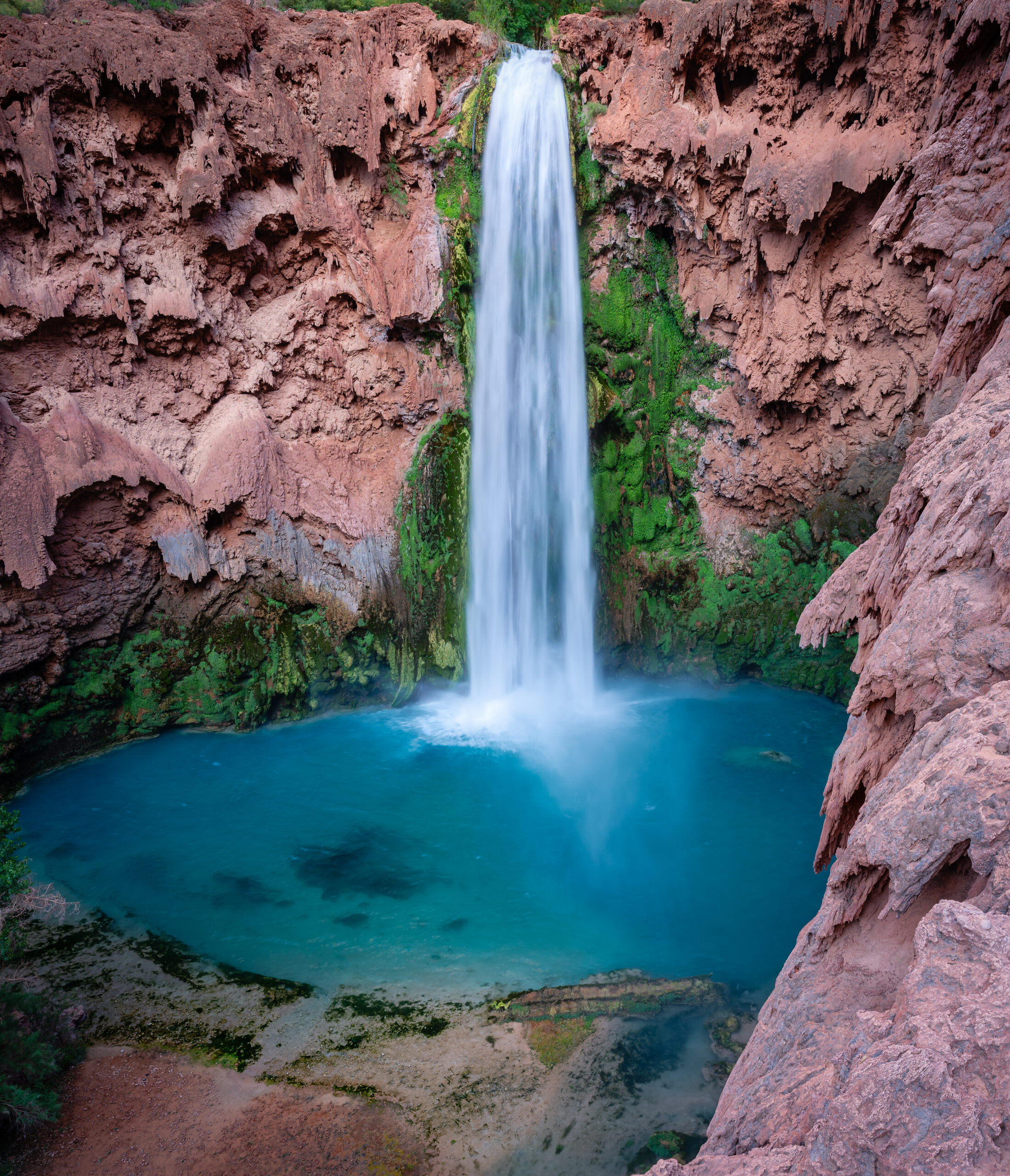
With both of the first two falls sufficiently explored, it was time to head to the campground and find a home for the next four days. The cliffs above Havasu Creek granted me a great vista to its teal water. The color is caused by high concentrations of calcium carbonate in the water. The minerals reflect sunlight, creating the aquamarine color. The word Havasupai translated to English means “The People of Blue-Green Water”.
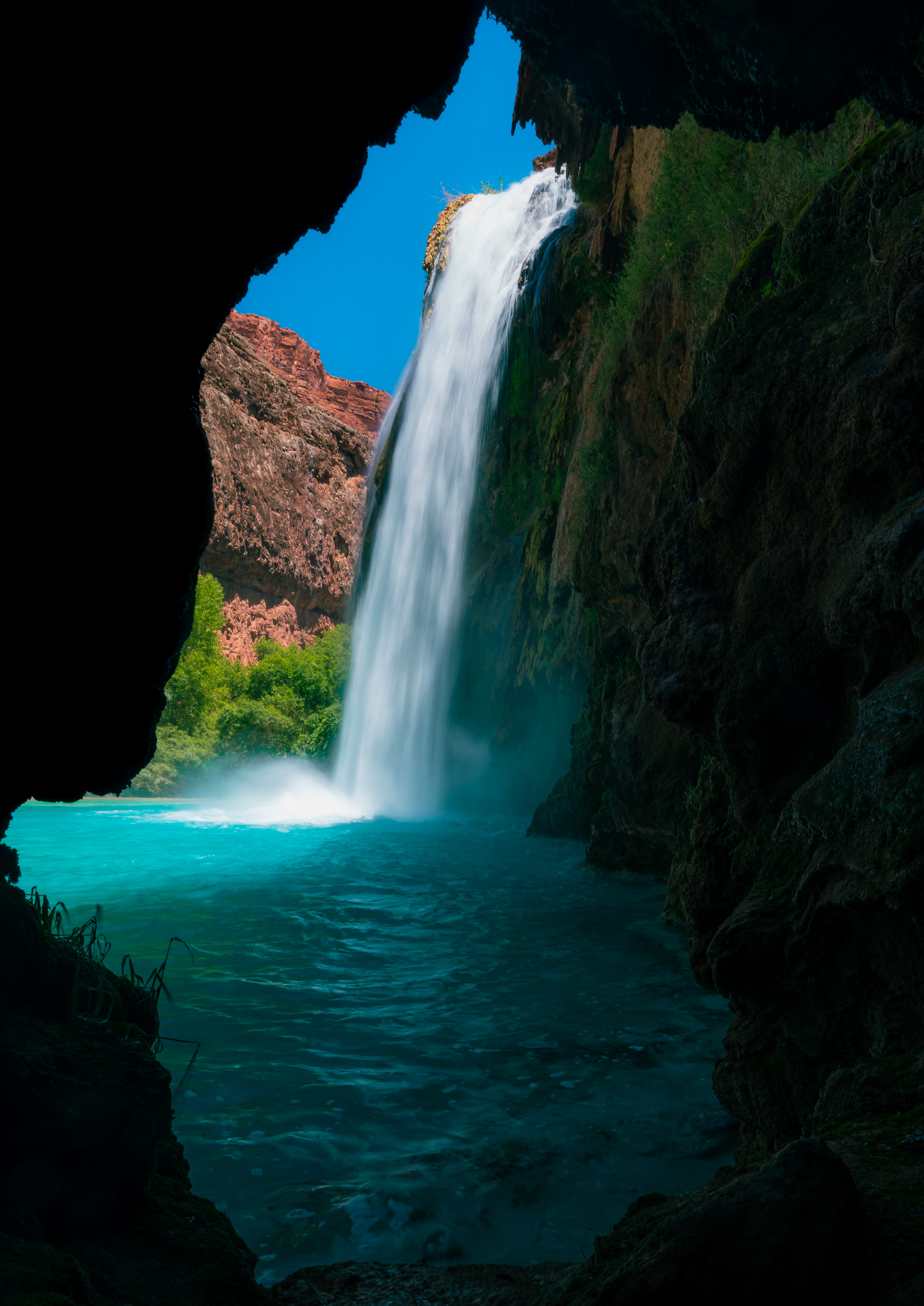
On the way to campground, I got my first glimpse at Havasu Falls. It is directly to the right of the trail, you couldn’t miss it if you tried. Seeing it up close, I understood why it is the iconic image of the area. I was tempted to go directly there, but I really needed to set up camp and drop some of my heavier gear.
After a short but steep walk past Havasu, I made it to the campground boundary. The campground is almost a mile long and extends from the ranger station to the top of Mooney Falls. There are no designated sites, but picnic tables and flat ground are common so it’s best to set up in a previously used spot. It’s slotted between narrow canyon walls, and Havasu Creek runs through it, sperateing one side from the other. Makeshift bridges are in place to get to the other side.
Fern spring is the only source of potable water in the campground and is located less than a tenth of a mile from the stary. It does not need to be filtered or treated.
There are three elevated composting toilets in the campground. One is near the entrance, one is in the middle, and one is near the top of Mooney Falls.
I found a good spot near the creek close to the top Mooney Falls. The location allowed me to filter water quickly without having to walk all the way to fern spring, and give me a slightly shorter hike to the confluence.
After setting up camp, the summer sun was out in full force. It was extremely hot, so I went back towards the main attraction.
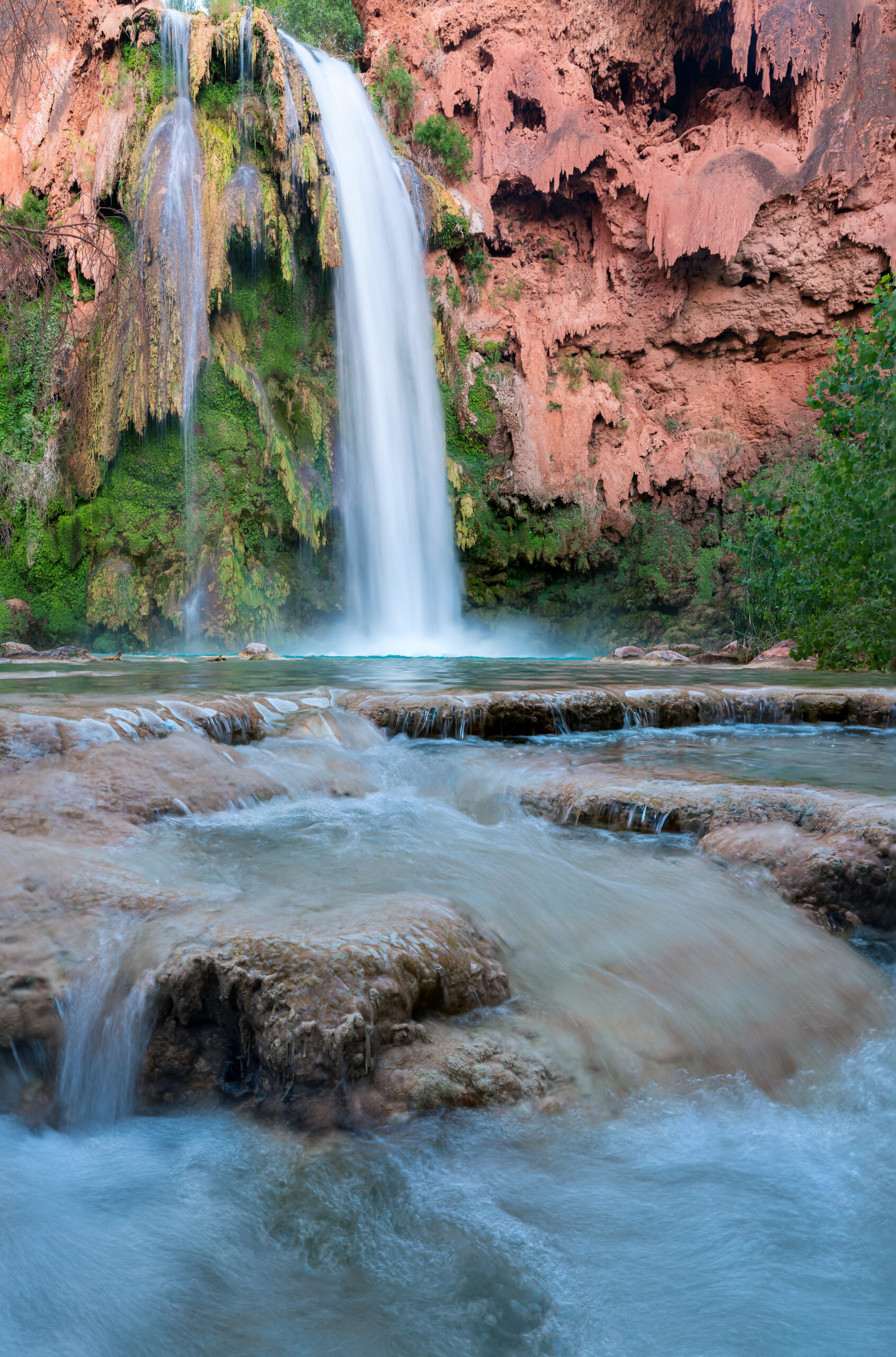
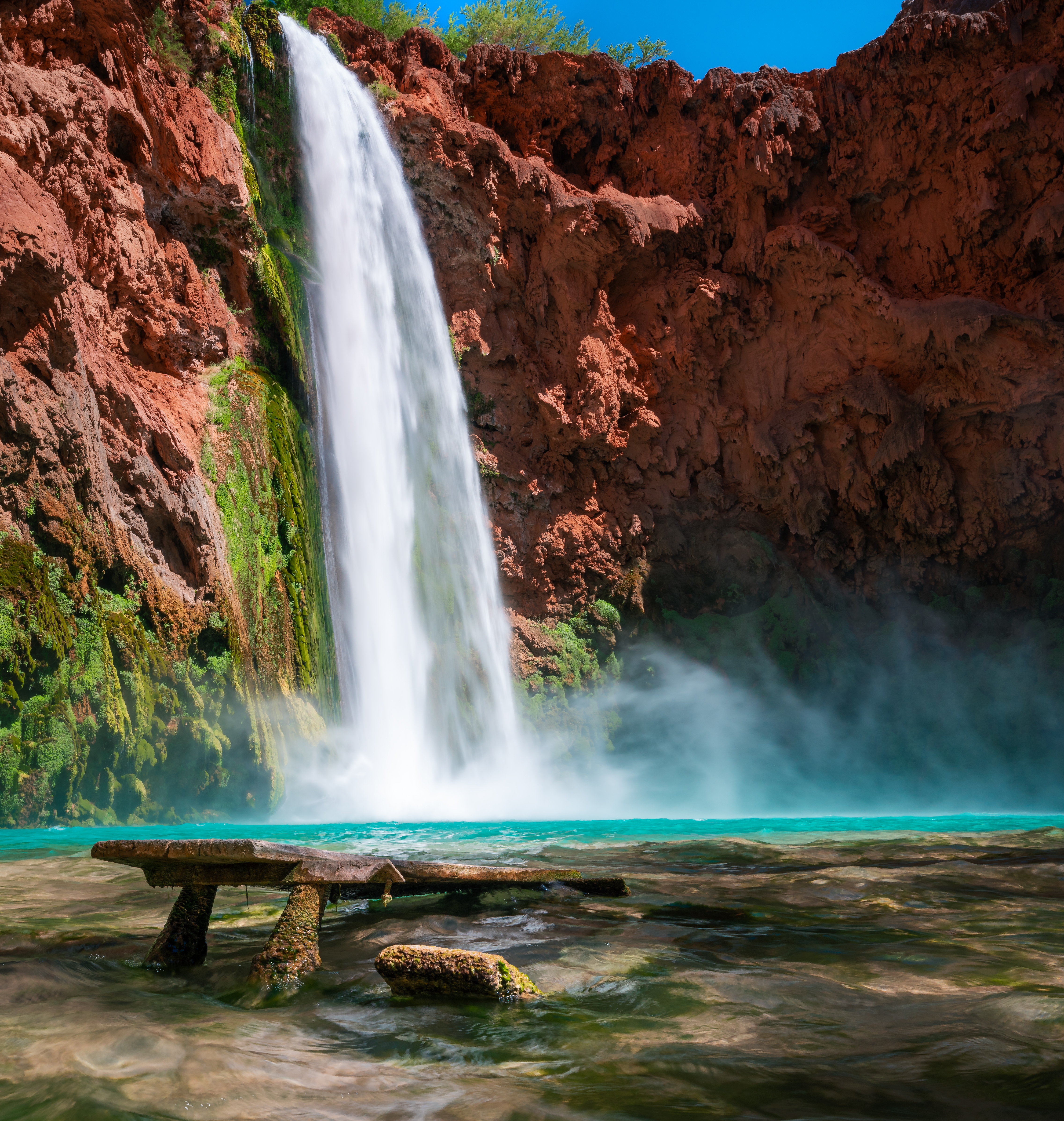
Havasu Falls – The most visited of the various falls along Havasu Creek. Located right before the beginning of the campground. It consists of two main chutes that drop over a 90 feet into a series of plunge pools. Due to flash floods, the appearance of Havasu Falls has changed many times. Before a 1910 flood, water flowed in a continuous sheet over a much wider area, and it was known as the Bridal Veil Falls. There is plenty of space for swimming and dry land for lounging and photography. I spent most of day one and day three of my hike here.
Day 2: May 29th, 2024
On the second day of my Havasupai hike, I followed Havasu Creek from the campground down to where it intersects with the Colorado River (aka the confluence). It is a 16-mile round-trip hike from the campground. I woke up before sunrise and packed only the essentials.
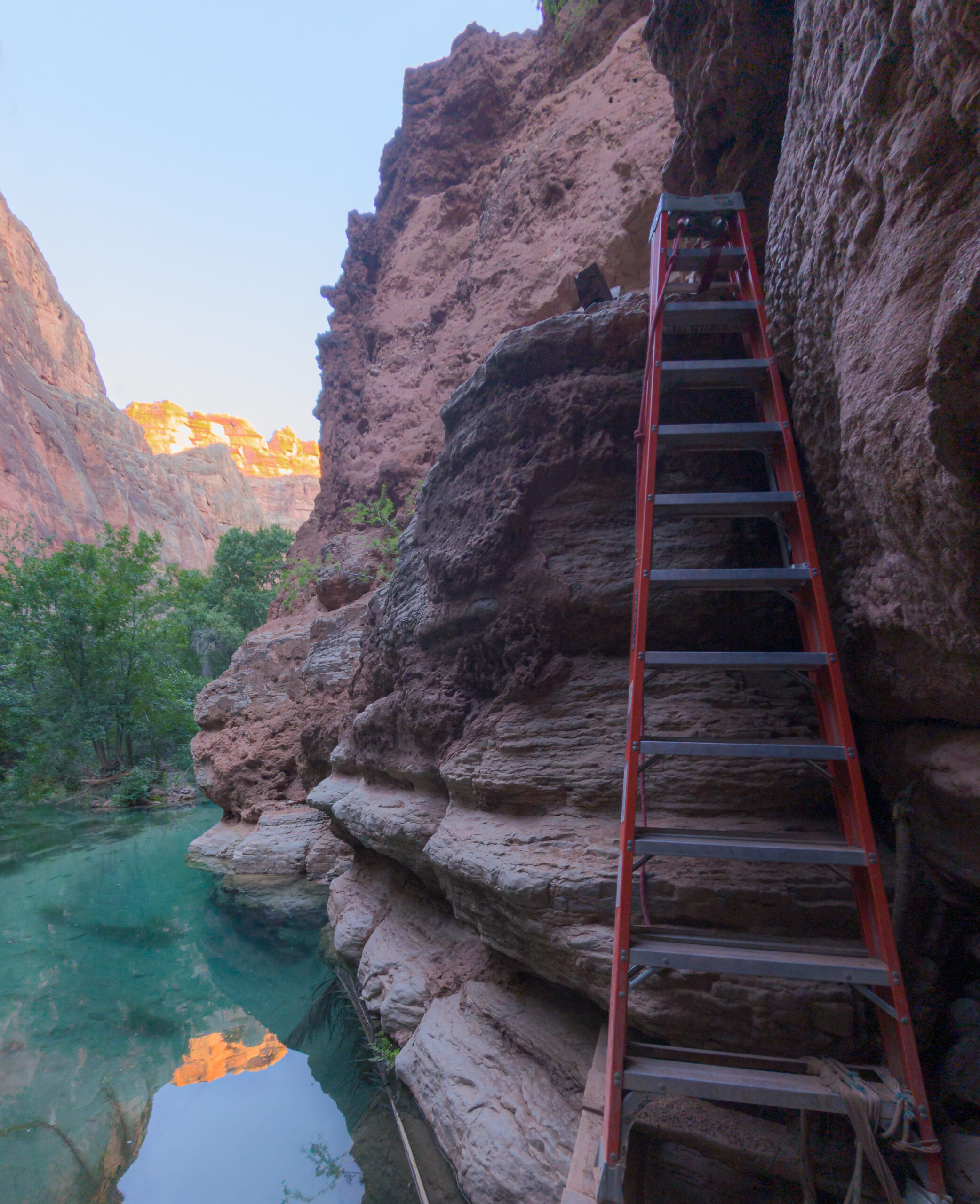
To get there I would first have to descend Mooney Falls. The hazards section later in this post will describe the descent in greater detail, but trust me, it is as terrifying as you’ve probably heard. I went down at 0430 hours, my headlamp illuminating only a few feet in front of me at any given time. In retrospect, I think this helped because it prevented me from seeing how far I had to go. On the way down, mist blanketed everything I touched. It felt like forever, but since I was only one climbing down that early, it probably only took a few minutes. The final ladder ended in a shallow pool near the falls. I’ve never been happier to be in wet socks than when I made it down. Off in the distance I could just start to trace the outline of the falls.
I did not spend any time at Mooney that morning, because I had a long way to go. The next stop on my journey was Beaver Falls. The trail winded through wild grape fields and creek crossings. It was hard to imagine an area so green and lush existing in Arizona. A literal oasis in the desert. It was in this section of the hike where I finally saw other people. A couple, resting near a picnic bench, were also heading to the confluence. At least I wasn’t the only one.
Eventually the trail went high again. There are some ladders and light rock scrambling up followed by a deep descent down to the 5th and final of the famous waterfalls.
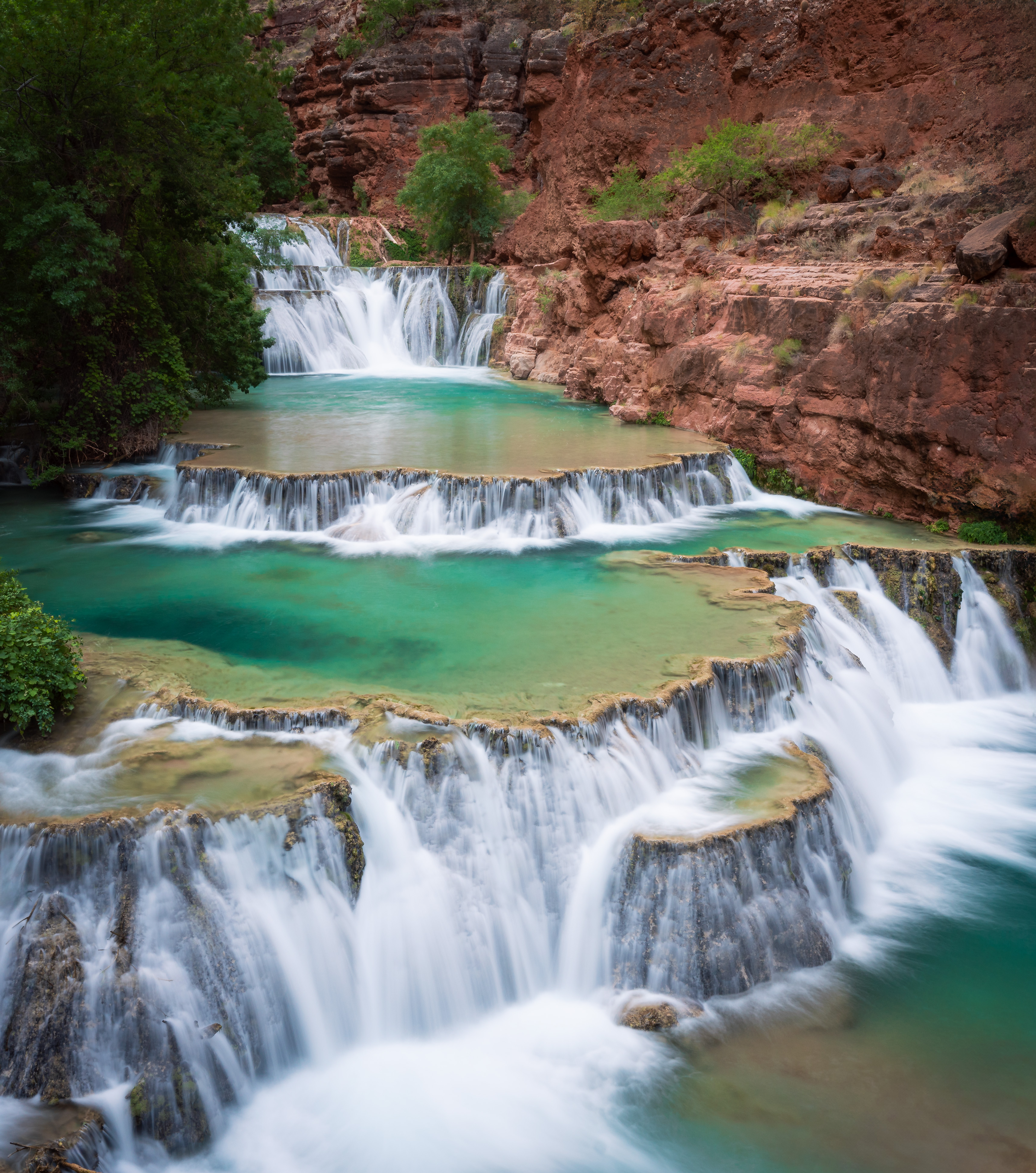
Beaver Falls – A series of terraces, Located at the edge the Havasupai Reservation. Due to the distance from the campground, it is probably the hardest of the falls to access. The pools are shallow enough to walk/swim in, and there are a few caves behind them. I arrived around 0700 hours and had it to myself. I got some great shots, and got in the water for a bit, but I did not stay long. On my way back from the confluence in the afternoon there were a lot of people swimming in it.
Right past Beaver Falls, there is a sign that indicates that you are leaving the reservation and entering the Grand Canyon National Park. The route goes even higher on the cliff before a few rocky switchbacks take you back down to the creek. I backtracked a few times until I found it.
From here, the trail is pretty easy to navigate. You cross the creek a lot, and cairns do a good job of letting you know you are on the right path. The water never got higher than my stomach, but the current can get pretty strong at times, I brought extra dry bags for my camera gear just in case I slipped. Surprisingly the creek is not very slippery. My water shoes had good traction each crossing and trekking poles helped me stabilize.
At one point I ran into a herd of bighorn sheep directly on the trail. I tried to wait them out, but they were not budging. They forced me to make an extra water crossing. I went right back into the creek and walked through it until I passed them up.
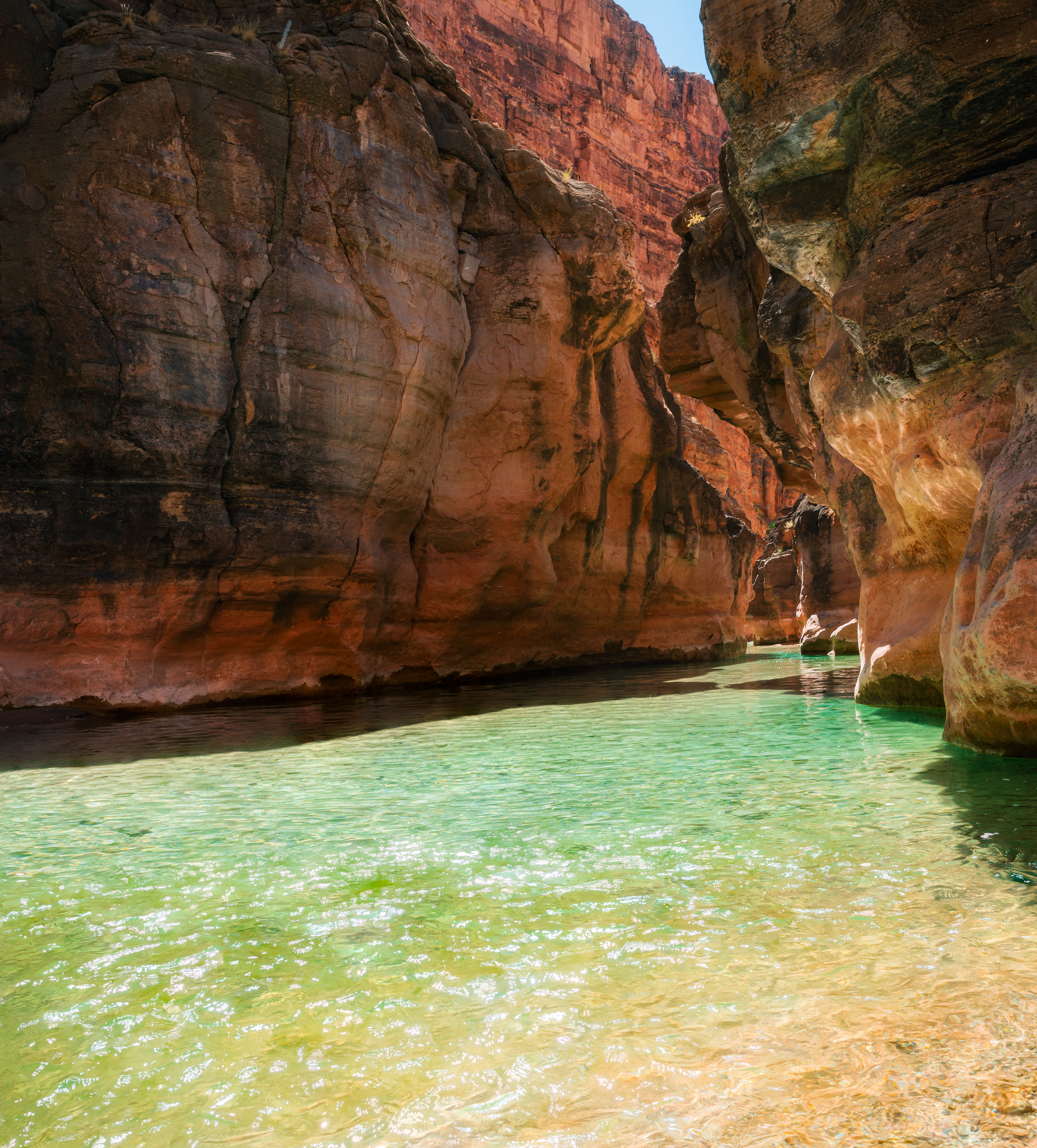
Right before the Colorado River, there are two ways to get to the confluence. The creek goes through a narrow part of the canyon and you can walk/swim through it to get there, or you can take the high route above. Both routes will take you to the same spot in the end.
At 0900 hours exactly, I arrived at my destination. I ate a nice long lunch, and admired the power of the river that formed this great canyon. Once the sun fully rose above the canyon, I then swam around in the confluence for a bit. The water is calm where the creek meets with the Colorado, and there are some pretty big fish that hang out in there. If anyone know what species swim in that section, please reach out. I could not find much information on that. It is usually a popular destination, but I must have been lucky because there were no kayakers or other hikers in sight. In fact, no one else showed up until I was already there for an hour.
Around 1030 hours, the once shaded canyon was fully exposed. It was time to head back. With the sun bearing down on me, I took a lot more breaks, filtering water at every other stream crossing. On my way to Mooney I passed maybe 6 other hikers who were heading to the confluence. With how hot it was, I was glad to be on the back end of the hike.
At one of the many unnamed falls between Beaver and Mooney, I happened to be in the right place at the right time and saw a bighorn sheep jumping over a set of falls to cross Havasu Creek. So cool!!!
Around 1430 hours, I finally made it back to largest of the 5 waterfalls, and got to experience it in all its glory.
Mooney Falls – Perhaps the most impressive and intimidating waterfall at Havasupai. Located at the far end of the campground, It towers over 200 feet tall and requires a terrifying descent to get there. Named after D. W. “James” Mooney, who in 1882 fell to his death trying to climb the falls. The plunge pool is the largest of all the falls, and the deepest.
I was here about an hour getting different composition of the falls and swimming in the pools. It wasn’t as crowded as Havasu Falls, but still had a good amount of visitors.
The climb up Mooney was not nearly as bad as the climb down, but there were a lot more people this time so it took longer. When I got back to the top I took a few more photos before going back to camp.
One last thing about the confluence hike, for my footwear I opted for a pair of Keen water shoes coupled with Darn Tough Socks and left my trail runners at camp. If you read my post about the amazingness about Darn Tough, you can already guess this decision was the right one. I did not have to remove my shoes every time I needed to cross the creek, and I suffered from a total of 0 blisters despite my feet being wet most of the time. If you do this hike, I would absolutely recommend this strategy.
Day 3: May 30th, 2024
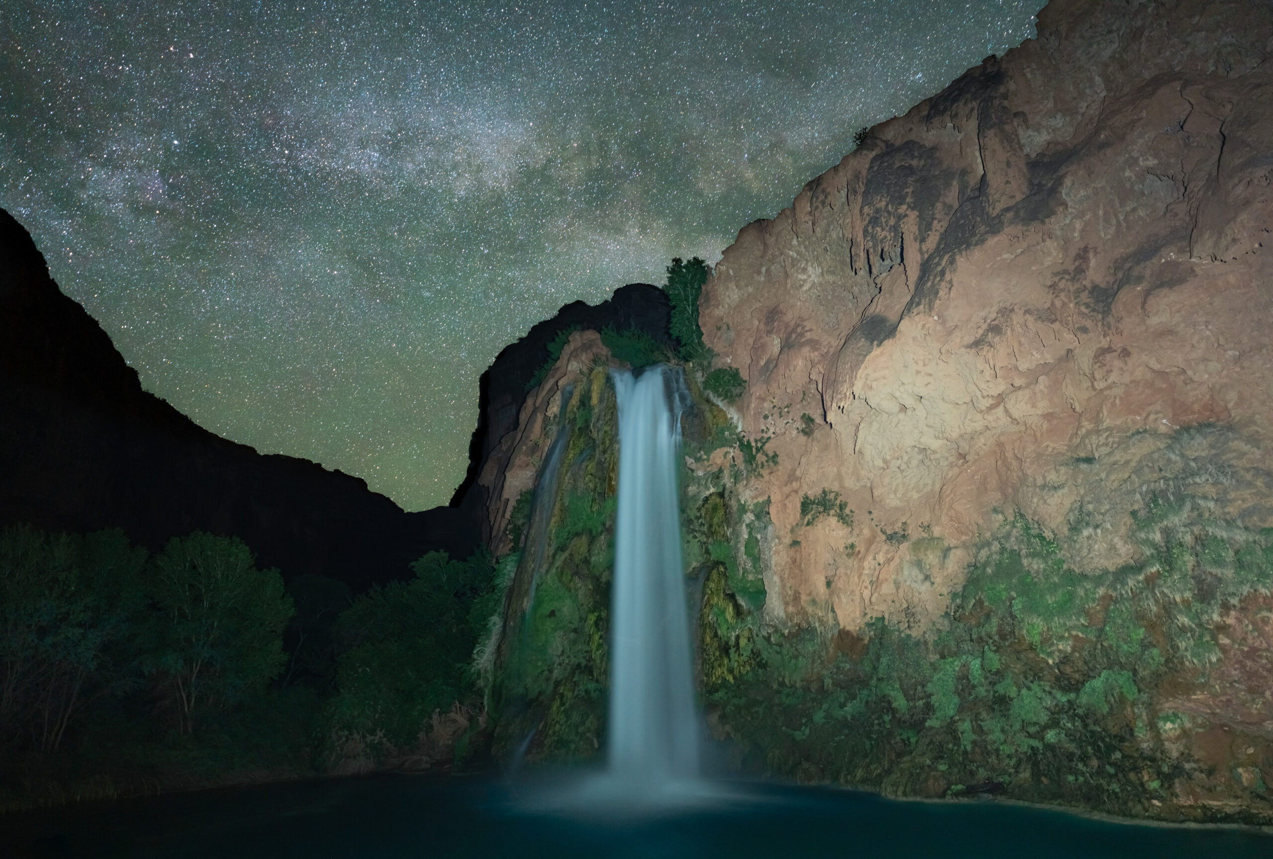
Despite the long day yesterday, I forced myself up at midnight to try and get a milky way shot over Havasu Falls. I grabbed my camera and tripod and made the trek through the campground to Havasu Falls. The temperature was cool with a nice wind, it was almost enough to make me forget how hot it was during the day. I set up shop right around where the water met land, just as the milky was was rising above the falls. I was there about an hour and a half taking various photos, using my headlamp to light paint the falls. Special shouts to Photopills for helping me plan the shot. Afterwards, I meandered back to camp and fell right back to sleep.
After waking up for the second time I spent all day relaxing by havasu falls. I had explored every other area, and I did not want to make that climb down Mooney again, so I spent all of day 3 just swimming and nodding off against a tree. It was a perfect recovery day and just how I wanted to spend my last full day there.
Day 4: May 31st, 2024
With the temperatures predicted to be close to 100F in the afternoon, my goal was to be on the road well before that. I left camp at 0200 hours trying to pack up as quietly as I could. Once I started hiking, it didn’t take too long to reach Supai. The town was almost silent, the only sounds coming from the mules in the distance. I noticed other hikers heading for the helicopter, which offers flights out out the canyon rather than hiking out. More information on that, here.
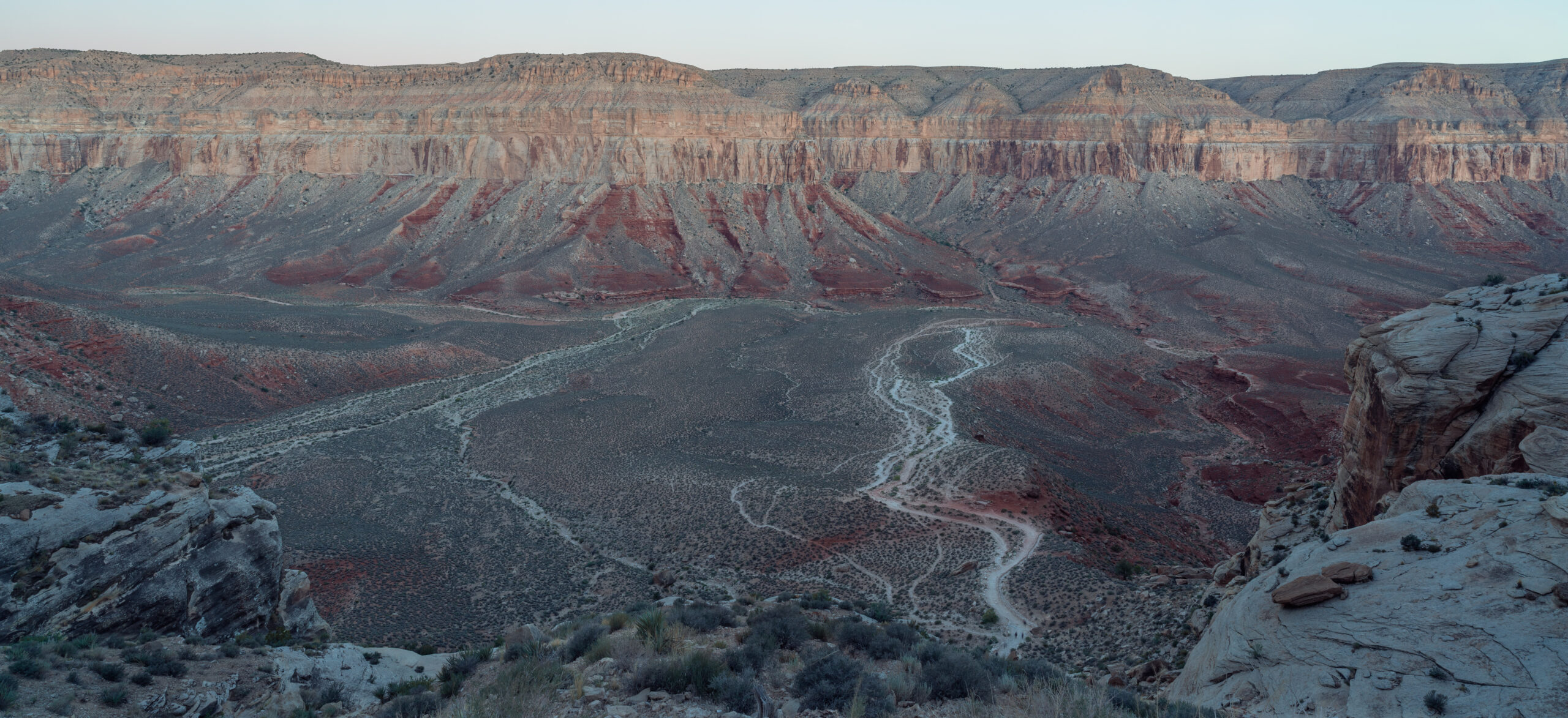
Midway up, the moon and stars gave way to a purple and cobalt sky that painted the canyon. It truly is incredible how many different colors are expressed depending on the time of day. I started running into the early birds coming down to begin their adventures. At 0630 hours, my adventure had come to an end. The last mile of switchbacks ended up not being nearly as challenging as the North Rim or Bright Angel Trail. I snapped one last shot of the valley below. The colors mixed together create an almost abstract work of art.
Part 3: Miscellaneous Details
Logistics:
The Havasupai reservation is in a very remote location. Indian Road 18 is the only road that leads to trailhead, and the closest gas station is approximately 70 miles away. You should have enough gas for 200 miles before going. Below is my itinerary.
- Day 0: I finished my 24 mile Phantom Ranch Hike and immediately drove 141 miles from the Grand Canyon south rim to the Grand Canyon Caverns Inn where the check-in booth for Havasupai is. I checked in, received my wristband and then checked in to the hotel where I stayed overnight.
- Day 1: I checked out of GCI at 0330 hours, then drove 82 miles to the Hualapai Hilltop via Indian Road 18. I found a parking spot and hiked 12 miles to the campground. I visited Fifty Foot Falls, Little Navajo Falls and Havasu falls along the way.
- Day 2: I woke up at 0430 hours, and hiked approximately 16 miles from the campground to the confluence and back. I visited Beaver Falls and Mooney Falls along the way.
- Day 3: I spent the day swimming and relaxing at Havasu Falls near the campground
- Day 4: I packed up camp at 0200 and hiked 12 miles back to Hualapai Hilltop . Made it to my vehicle at 0630 hours.
Listed below are the closest airports to the trailhead.
-Las Vegas McCarran International Airport, Nevada (LAS): This is probably the best option for flying when you factor in price. It is approximately 220 miles; a 3 hour 45 minute drive.
-Phoenix Sky Harbor International Airport (PHX): It is approximately 263 miles; a 4 hour 20 drive to Hualapai Hilltop. I flew out of here because I have a friend in Phoenix who let me stay at his place after my hike to shower and rest up before my flight home.
-Flagstaff Pulliam Airport (FLG): This is the closest, small commercial airport to Hualapai Hilltop. If you can afford it, this would be the ideal airport to fly into. It is approximately 161 miles; a 2 hour 48 minute drive to the trailhead.
Water:
There is no water source until you reach the lodge or campground depending on where you are staying. Each is over 10 miles from the trailhead, so make sure to have enough for this section. Once you reach the campground, there is a spigot near the beginning of the campground with potable water and the creek runs alongside the campground. I camped pretty far from the spigot so I mostly filtered water directly from the creek.
If you make the trek to Beaver Falls or the confluence, you will be hiking both alongside Havasu Creek the entire way with numerous water crossings. I brought my filter and collected water directly from the creek as I hiked.
Navigation:
From Hualapai Hilltop to Mooney Falls, the trail is easy to follow. It is a wide, well-defined path. Without blazes or much signage, it is difficult to get lost.
From Mooney Falls to Beaver Falls, the terrain changes. It involves walking through some wild grape fields and crossing Havasu Creek a few times. It is a bit more challenging, but still not difficult to follow.
Hiking to the confluence was the most difficult section in terms of navigation. The Havasupai reservation ends immediately after Beaver Falls, and from there the land is a part of the Grand Canyon National Park. The trail can be hard to find after this, but the creek is always nearby and there is only one way to go. Along the way, dozens of cairns help mark the path. Be prepared for approximately twenty creek crossing from Mooney to the Confluence and back.
Difficulty:
Havasu Falls is an extremely popular hike that attracts people of all experience levels. Aside from the switchbacks at the very beginning/end the trail is mostly flat with minimal elevation gain. Adding the confluence section makes it more of a challenge, but I found navigating more difficult than the hike itself. Probably the most challenging part was descending down to Mooney Falls, but it was more terrifying than physically hard. I would classify the difficulty of this hike as moderate.
Hazards:
Heat – During the summer, temps at the campground can reach over 115F. I went at the end of May and every day i was there, it was close to 100F at the hottest part of the day. One upside to this is with the creek and waterfalls nearby it feels amazing to get into the water on those sweltering days
Monsoon Season/Flash Floods – Flash floods can occur anytime of year, but monsoon season at Havasupai Falls is from late June into early September. There is a higher risk of flooding during this time of year. Heavy rains and flooding may cause evacuations.
Mooney Falls Descent/Ascent – To get from the campground to the base of Mooney Falls, Beaver falls, and the confluence, you must first make a 200 foot vertical descent from the top of the cliff down to the pool below. It is a narrow, treacherous path that includes two small caves, “steps” cut into the rock, and chains attached to spikes in the rock. If all that doesn’t scare you, Mooney casts a heavy mist that will coat you, and the previously mentioned chains, steps etc. In addition to all that, there’s only room for one person at a time. This creates a bottleneck at different times during the day. I went down at 0430 hours and was the only one, whereas at 1530 hours when i climbed up, I was waiting in the cold mist for 20+ minutes before getting to climb up.
Camping/Lodge Permits:
Permits for this hike are 100% mandatory, (no walk-ins/day hiking is allowed) . Getting a permit is probably the most difficult part of the trip, as most sell out the first day reservations open.
When I applied in 2024, the Havasupai Tribe introduced a new presale system. It opened at 0800 hours Arizona time on January 5, 2024 and ran through 1700 hours Arizona time on January 18, 2024. This allowed me a chance to purchase reservations before the public. During the presale, I registered for the campground on my three requested start dates, as well as a designated month if my start dates were not available. The presale required a non-refundable fee of $15, and reservations were not guaranteed. Those who were not successful getting presale permits still were able to try and get one on opening day when they opened to the general public.
In 2024, the price for a permit was $455 per person for 3 nights at the campground. Payment is due in full when the reservation is confirmed and can include up to twelve people. There is only one name on the reservation, and that person on the reservation needs to be at check-in. Reservation transfers are available for a 10% fee.
Check-in for all reservations is located at the Grand Canyon Caverns Inn, located at Mile Marker 115, Route 66. It is at the rear of the hotel main entrance. You must go there either the day before your arrival date or no later than noon on the first day of your reservation. Failure to do so will result in your reservation being cancelled. No refunds or rescheduling will be granted. It is usually open from 0800 to 1700 hours every day.
The trip leader will need to provide photo ID to receive all permits, wristbands, bag tags, etc., which will need to be completed and shown to the Havasupai Reservation checkpoint staff on Indian Road 18.
If you want to book a room at the lodge instead of the campground, Reservations typically open up on June 1st. Please be aware though your lodge reservations will be will be for the following year.
If you are unable to get permits from the presale or opening day, you can still get them if you are flexible. You can check for cancellations and available permits throughout the year. At 0800 hours Arizona time everyday new cancellations and transfers are posted on the website.
To apply for permits, or for more details, visit the official Havasupai Reservations site.
Whew!!! I know that was a lot, but trust me its worth it.
Wildlife:
Lizards, snakes, and invertebrates like spiders and scorpions all make their home in the Grand Canyon. Mountain Lions do as well, but encounters are extremely rare. If you hike to or past Beaver falls there is a good chance you will see bighorn sheep like I did.
The most problematic wildlife encounters you are likely to have are with the squirrels at camp. They are ruthless, when I first picked my spot out, I set my backpack down and 30 seconds I caught one chewing a hole through my shoulder pocket. After this, I promptly put my food and smelly items in my bear can and never had an issue the rest of the time.
Last Word
Despite the difficulty and costs in getting permits, this hike is not one to be skipped. I cannot stress enough how unique and beautiful the Havasupai land is. Both avid backpackers and day hikers will find plenty to explore over four days.
If you are looking for solitude, then this probably isn’t the hike for you; however, I did manage to have all five waterfalls, and the confluence to myself for an extended amount of time. I just got myself up before sunrise and after sunset to make it happen.
Lastly, the Havasupai Reservation is a special place, please recognize that it is tribal land, and it is a privilege to be invited in. We are visitors in their home. Be respectful of the rules and their land. Please adhere to the Leave No Trace principles.
Thank you for reading. If you enjoyed this, and want to check out my other stuff, you can do so right here.